GIS & Mapping: Next-Gen Permaculture Design Tools
By Permaculture Institute of North America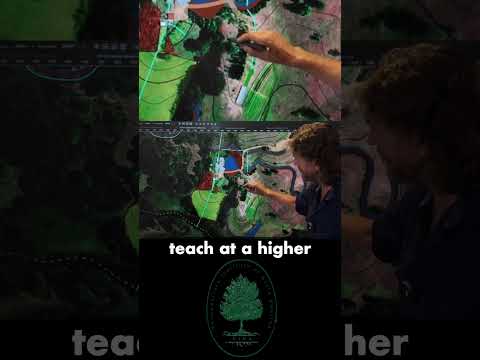
TL;DR: Digital mapping tools enhance permaculture design by offering precise site analysis and visualization beyond traditional methods.
- Utilize Google Earth for historical site changes and existing features.
- Leverage USDA Web Soil Survey for detailed soil data and agricultural suitability.
- Employ GIS software like QGIS for layering diverse site data.
- Integrate topographical, water flow, and microclimate data for holistic design.
- Move beyond hand-drawn sketches for more dynamic and data-rich designs.
Why it matters: Modern mapping technology provides permaculture designers with advanced capabilities for site assessment and detailed planning, leading to more effective and regenerative systems. This precision minimizes errors and maximizes ecological benefits.
Do this next: Watch the video to explore specific applications of these mapping tools in permaculture design.
Recommended for: Permaculture designers and enthusiasts looking to integrate modern technology into their site analysis and planning processes.
Permaculture design, at its core, involves thoughtful observation and strategic planning to create regenerative systems. Modern technology offers a suite of mapping tools that can significantly enhance this process, moving beyond traditional hand-drawn sketches to provide more precise, data-rich, and dynamic representations of a site. These tools can be broadly categorized into those that help with initial site assessment and those that aid in detailed design and visualization.
For initial site assessment, tools like Google Earth and the USDA Web Soil Survey are invaluable. Google Earth provides a bird's-eye view of a property, allowing designers to quickly identify existing features such as buildings, roads, water bodies, and significant vegetation. Its historical imagery feature is particularly useful, offering insights into how a site has changed over time, which can reveal patterns of erosion, past land use, or the development of tree cover. This historical perspective can inform decisions about water management, soil remediation, and the placement of new elements. The USDA Web Soil Survey, on the other hand, offers detailed information about soil types, their composition, drainage characteristics, and suitability for various agricultural uses. Understanding the soil is fundamental to permaculture, as it dictates what can be grown, how water will infiltrate, and where earthworks might be most effective. This data can guide decisions on plant selection, the need for soil amendments, and the design of swales or terraces.
Moving beyond these foundational tools, more specialized mapping software can be employed for detailed design. Geographic Information Systems (GIS) software, such as QGIS (an open-source option), allows for the layering of various data sets. A designer can import topographical maps, soil data, water flow patterns, sun path analyses, and even microclimate information into a single project. This layering capability enables a holistic understanding of the site's dynamics and helps in identifying optimal locations for different permaculture elements. For instance, by overlaying sun path data with topographical information, a designer can pinpoint the best spots for sun-loving plants or areas that will remain shaded during hot periods. Similarly, combining water flow data with soil types can inform the placement and design of water harvesting systems.
Another powerful category of tools includes those for creating contour maps and analyzing elevation. While some GIS software can generate these, dedicated surveying tools or even drone-based mapping can provide highly accurate elevation data. Contour maps are crucial for designing earthworks like swales, terraces, and ponds, as they illustrate the natural flow of water across the landscape. Understanding the slope and aspect of different areas is vital for effective water management and for optimizing solar gain for structures or planting zones.
Furthermore, tools for visualizing and communicating designs are becoming increasingly sophisticated. While 2D maps are excellent for planning, 3D modeling software can bring a design to life, allowing clients and stakeholders to better understand the proposed changes. Some permaculture-specific design software, or even general landscape design programs, offer features to simulate plant growth over time, visualize water flow, and even estimate material quantities. This not only aids in communication but also helps in refining the design before any physical work begins, potentially saving time and resources.
In essence, these mapping tools empower permaculture designers to move from intuitive observation to data-driven decision-making. They facilitate a more comprehensive understanding of a site's unique characteristics, enable more precise placement of elements, and allow for better visualization and communication of complex designs. By leveraging these technological advancements, permaculture practitioners can create more resilient, productive, and truly regenerative systems.